


Event
Emesent GX1 Demo Day Canada 2027
Join Emesent and TSS Canada in Toronto this March
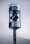
Emesent and Technology Support Services Canada are organizing a free, hands-on demo day featuring two of our SLAM-based LiDAR mobile mapping systems: the brand-new Emesent GX1 and the Hovermap STX.
The Emesent team will be on hand throughout the day to demonstrate both systems and discuss how they fit into your existing workflows. Explore the GX1’s all-in-one capabilities, combining SLAM-based LiDAR, 360° color imaging, and RTK, alongside the Hovermap STX.
Date: Tuesday, March 16, 2027
Location: The Old Mill, Toronto, Canada
Time: 10:00 a.m. - 4:30 p.m.
Registrations close March 9, 2027.
What to expect:
-
Exclusive chance to win a week with a Hovermap STX - Every attendee will be entered into a drawing for a chance to use a Hovermap STX on their own projects for one week.
-
Hands-on GX1 and Hovermap STX stations - Pick up the devices, capture data using the tablet, and follow a real-world scan from first step to finished result.
-
Product presentations - Emesent and TSS Canada set the scene with an overview of Emesent products and solutions.
-
Aura and Aura Cloud post-processing and third-party workflow integrations - See how raw scan data becomes the deliverable you need and flows into software you already use, including Trimble Business Center.
-
Start with the deliverable - Work backward from the output you need to identify the right data capture approach. We’ll show you the workflow, not just the hardware.
-
Open Q&A - Bring your own projects and challenges and get straight answers on the spot.
-
Complimentary catered lunch - Take a break, meet industry peers, and talk with the Emesent and TSS Canada teams.
See what GX1 and Hovermap can do across different sectors:
-
Surveying: Highly accurate SLAM data and dense point clouds, with georeferencing built into the workflow so fewer manual steps stand between the field and the final deliverable.
-
Construction: Capture detailed 3D models quickly to support design, planning, and on-site progress tracking.
-
Architecture: Turn buildings and structures into precise 3D records that speed up design, renovation, and documentation.
-
Government and public services: Map hazardous or inaccessible areas in real time, giving search and rescue, damage assessment, and firefighting teams clearer situational awareness.
Register now to secure your spot!