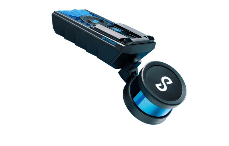
Emesent’s Award-Winning Hovermap

Fast, accurate, high-detail mobile data capture

Hovermap incorporates the latest in LiDAR sensing technology to offer high density point clouds with exceptional coverage. Featuring a sensing range of up to 300 meters and more than a million points per second, Hovermap captures detailed, accurate data over a wide area fast – accelerating your time to insight.

Emesent offers a choice of Hovermap business plans designed to match and support your specific LiDAR mapping and data visualization requirements.

Compare Business Plans

Why choose Hovermap

Fast time to insight

A LiDAR sensing range of up to 300 meters and triple returns capable of more than one million points per second allow you to capture detailed, accurate data over a greater area in less time – increasing efficiency.

Survey-grade Accuracy

The award winning Wildcat SLAM solution, Automated Ground Control Points and higher resolution LiDAR sensor provide a cleaner point cloud with sub-centimetre precision allowing you to obtain more accurate measurements and improved insights.

uniquely versatile

The plug and play design and quick-release mechanism allow easy switching between modes. Use Hovermap as a handheld scanner; attached to a drone, vehicle, or pole; lowered in a cage; or mounted to a backpack to easily collect data anywhere. The compact, lightweight design makes it easy to carry and provides longer flight time.

Superior detail

Capture shadowless, detailed, high quality point clouds of an entire complex asset with high density data sets to reveal richer features. Add a level of reality capture with Colorization.

Mapping options for every scanning need

Hovermap’s autonomy levels give you the versatility to best capture the environment you need and the confidence to leave the site knowing you’ve captured everything you need. In all modes, Hovermap streams a live point cloud to the Hovermap app, providing a real-time preview of the data as it is captured when in communication range.

Autonomous Waypoint Mode

Autonomous Waypoint Mode provides beyond line of sight flight through Smart Waypoints and Guided Exploration. Simply tap on the map to set smart waypoints, and Hovermap takes care of the rest, navigating to the waypoints, mapping the area, and keeping itself and the drone safe from obstacles.

Pilot Assist Mode

Pilot Assist Mode provides omnidirectional Collision Avoidance, line of sight GPS-denied flight capability, and stability control, providing the confidence and stability for close, thorough inspections. It acts as a safety bubble for your drone, keeping the asset and your equipment safe.

This mode is available in the Plus Subscription.

Mapping Mode

Mapping Mode offers fast, accurate, and high resolution mobile scanning of environments where drone autonomy is unnecessary. Hovermaps quick-release mechanism allows you to easily switch from a drone to handheld scanning or a backpack-, vehicle-, or protective shaft scanning cage-mount for SLAM-based mobile mapping.

Wondering how Hovermap can streamline your mapping workflows?

Leading LiDAR Mapping

DESIGNED FOR TOUGH MISSIONS

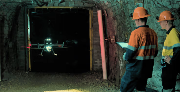
All Hovermaps in the ST product range are designed with the tough, lightweight, IP65 weather sealed design giving you the confidence to capture harsher areas. The award winning Wildcat SLAM solution and Emesent autonomy algorithms ensure safety for the drone and asset, even in hazardous, GPS-denied environments.

deployment options to suit your needs

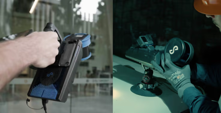
Hovermap’s unique versatility allows users to capture data from previously inaccessible areas, either from the air or on the ground. The plug and play design enables easy switching from drone-based use to handheld, backpack, vehicle or ground robot-mounted scanning.

Robust, autonomous capability

Autonomy modes designed to suit your needs with pilot assist with omnidirectional collision avoidance or beyond line of sight Guided Exploration.

Robust LiDAR scanner
Real time 3D point clouds

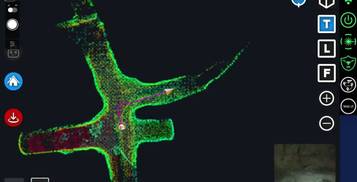
Live streamed point clouds

Hovermap streams the live point cloud to the Hovermap app, allowing a real-time preview of the data as it is captured.

Designed for fleet expansion

Accessories are compatible with both Hovermap ST and ST-X, meaning if you expand your Hovermap fleet, you can use the same accessories on different Hovermaps.

Hovermap accessories

Automated Mission Control

Emesent Commander makes mapping, pilot assist and autonomous mission planning and control effortless. Designed with user-friendly workflow prompts and built-in fail safes, the Commander app gives you responsive control, ease of navigation and access to Emesent’s market leading autonomous capabilities via a touchscreen interface.

Point Cloud Processing

Emesent Aura allows the processing and visualization of scans in one intuitive platform, streamlining the way Hovermap users process, view, and analyze point clouds for faster insights and improved decision-making.

Hovermap Specifications
Mapping Specifications
LiDAR range
0.40 to 100 m (1.3 to 330 ft)
Mapping Accuracy
± 20 mm (3/4 in) in general environments ± 15 mm (19/32 in) in typical indoor and underground environments ± 5 mm (7/32 in) isolated change detection capability
LiDAR Channels
16
LiDAR Data acquisition speed
Single Return Mode: up to 300,000 points/sec Dual Return Mode: up to 600,000 points/sec
Storage
512 Gigabytes – approximately 8 hours of sensor data
Physical Specifications
Weight
1.6 kg (3.5 lb)

Want to Learn more?


Contact us now

See Hovermap in Action


Book a Demo